Share this page:
The Cape York Peninsula is a large and remote area in the far north of Queensland, Its eastern coast borders the Coral Sea; its western coast borders the Gulf of Carpentaria. Cape York Peninsula includes a large unspoiled wilderness area that is one of the largest remaining wilderness areas in the world.
Large areas of almost undisturbed eucalyptus wooded savannahs, tropical rainforests, tropical heathlands and wetlands have been recognized by scientific experts as having a huge and unique biodiversity and a major environmental importance for the whole world. Unfortunately, about half the Cape is used for cattle grazing and introduced (that is, non-native) species and weeds are threatening the Cape’s native fauna and flora.
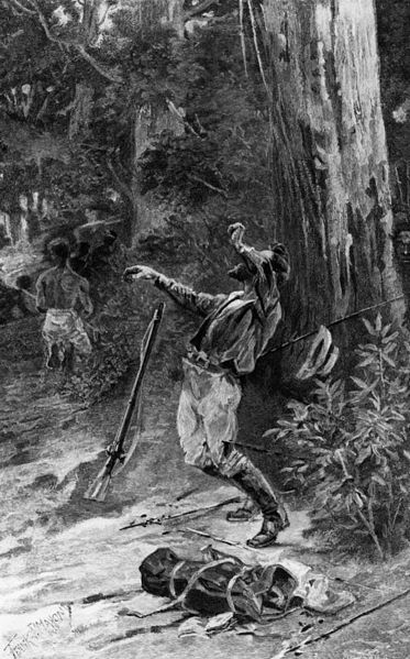
Death of the explorer, Edmund Kennedy, near Escape River, Cape York Peninsula, circa 1848.
A Little History
Early contact between outsiders and the Aboriginal inhabitants occurred as early as 1606, when the Dutch navigator, Willem Janszoon, sailed into the Gulf of Carpentaria.
The British navigator, Captain James Cook, sailed along the coast in 1770. It was he gave the Cape York Peninsula its name (he named it after Prince Edward, Duke of York, a brother of King George III of England). He also named the Endeavour River (where he beached his ship, the H. M. Bark Endeavour, for repairs for a period of seven weeks).
In 1848 the explorer Edward Kennedy was sent to blaze a trail to the very northern tip of Cape York. The expedition set out with 13 men from Rockingham Bay (between modern day South Mission Beach and modern-day Cardwell) but 10 out of the 13 were to perish. This included Kennedy who was speared to death by hostile Aborigines near Escape River, just 20 miles from the tip of the Cape. Kennedy’s faithful Aboriginal companion, Jackey Jackey, trekked out of the area and brought help for the two remaining survivors.
A trail was finally blazed to the tip of the Cape in 1864-65 when the Jardine brothers (from whom the Jardine River in Cape York Peninsula takes its name) drove a herd of cattle from to the new settlement of Somerset.
Geography
The central backbone of the Cape York Peninsula is the Peninsula Range, which is part of the Great Dividing Range.
On the eastern side of the Peninsula Range, a series of short, fast-flowing rivers including the Lockhart River and the Endeavour River flow down to the Coral Sea. These rivers are in a very undisturbed state and take important fresh water and nutrients to the Great Barrier Reef. Along the way these rivers are lined with thick rainforests, sand dunes and mangroves.
On the western side of the Peninsula Range, a series of larger, slower, winding rivers, including the Mitchell River and the Jardine River, flow to the Gulf of Carpentaria. In the wet season these rivers swell to mighty waterways while in the dry season they are reduced to waterholes and dry sandy riverbeds.
The water flows and the vegetation cover of these rivers is virtually intact, a most unusual thing anywhere in the world. They contribute much to the maintenance of species and help replenish central Australia’s Great Artesian Basin. The Queensland government aims to protect the integrity of 13 of these unique wild rivers via its Wild Rivers Act 2005.
Flora
Cape York Peninsula is home to some 3,300 species of flowering plants and an amazing 99.6% of the Peninsula still retains its native vegetation. There is a huge amount of 260 of these plants are endemic (that is, found in no other place on earth).
Fauna
The Peninsula has 740 species of land animals (of these, 40 are endemic, that is, the species are found nowhere else). They include all sorts of birds, 200 species of butterfly, and many more. Each habit – rainforests, river banks, rivers, wetlands, coastal mangroves – support a range of wildlife of their own, include many endemic species.
Threats to Fauna and Flora
Overgrazing from broad acre cattle farming (cattle ranches occupy 57% of the Cape), damage from bauxite and sand mining, out of control fires, introduced pests such as feral pigs and cane toads, and weeds – all these represent a danger to the Cape.
Yet right now the environment remains in very good shape, but to ensure this is protected the Queensland and Australian Governments are considering nominating the wilderness for a World Natural Heritage status. This would be in addition to the various national parks already existing in the Peninsula and in addition to the Wild Rivers Act 2005.
Towns
The main administrative area for the Cape York Peninsula is Cooktown. The largest settlement is the mining town of Weipa. Other towns include Laura, Lakeland, Coen, and Thursday Island.
Aboriginal communities include Hopedale, Kowanyama, Aurukun, Lockhart River, Injinoo, and New Mapoon. Torres Strait Island communities include Bamaga and Seisia.
Aboriginal Rock Art
Significant Aboriginal rock art may be seen in the vicinity of Laura. To assist with your understanding, you can visit the Interpretive Centre in Laura and arrange to be taken on a guided tour.
Share this page:
Author: David Paul Wagner
(David Paul Wagner on Google+)
|