Australia For Visitors > Uluru-Kata Tjuta National Park, NT
Uluru-Kata Tjuta National Park
Northern Territory
Share this page:
Uluru (also known as Ayers Rock)
Uluru, the great rock in the center of Australia, is the country's most popular and most visited tourist attraction and is one of the world's great natural wonders.
Located around 470 km from Alice Springs, Northern Territory, Uluru is a sandstone monolith (that is, one huge formation of sandstone) and rises 348 meters above the surface of the surrounding sandy scrub plains. It is 3.6 km long and 2.8 km wide. It is also an 8.8 km walk around its base.
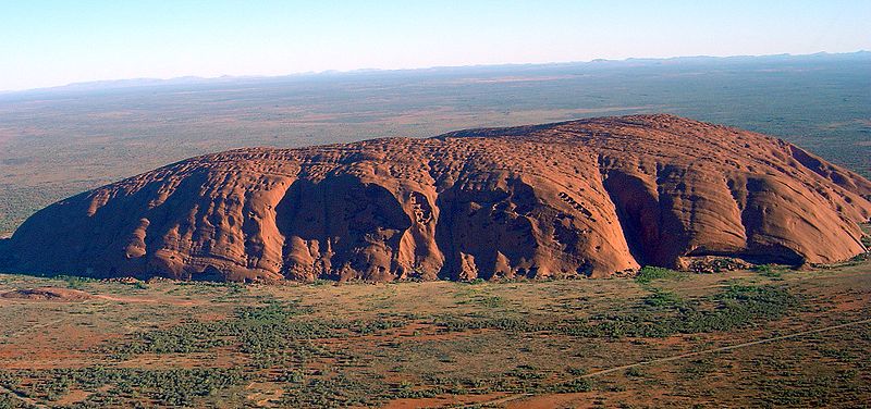
Uluru (or Ayer's Rock) as seen from a helicopter
Interestingly, the rock (somewhat like an iceberg) is mostly hidden -- two thirds of it remains beneath the surface.
For tourists, the huge elemental presence of Uluru, along with its ever-changing colors, is what fascinates. During daylight, the rock is red; as it approaches sunset, the rock turns various shades of dark red and then it goes gray.
For Aborigines, whose forebears have lived in this area for more than 10,000 years, Uluru is a sacred site. It is part of the dreaming trails and incorporates important ceremonial and burial sites which date from the times of the Aborigines' ancestors.
A Little History
Uluru is located in the traditional lands of the Yankunytjajara and Pitjanjatjara tribes of Aborigines. Apart from being sacred for them, Uluru has provided the Aborigines with a sources of water -- in the form of almost permanent waterholes) in this extremely arid (dry) environment -- and food.
In 1872, the explorer Ernest Giles became the first European to see Uluru. In 1873, William Gosse and his Afghan assistant were the first to climb Uluru. Gosse named the rock "Ayer's Rock" after the then Chief Secretary of South Australia, Sir Henry Ayers. Since the 1980s the rock is mostly becoming known by all, Aborigines and Europeans alike, under the Aboriginal name "Uluru".
In the late 19th century the Aborigines were "relocated" from this area, their traditional lands, to make way for the stock (cattle) of European pastoralists.
In 1958 a National Park was created around Ayer's Rock (as it was then known to the whitle community). In 1985, following a long court battle, the area was returned to its Aborigine owners (the Yankunytjajara and Pitjanjatjara tribes), but this "give back" was done on condtion that the land would immediately leased back to the Department of Environment and Heritage. Tourism has continued unabated and in fact has vastly increased, but at least the area is now co-managede by the Aboriginal people.
Tours
There are some free tours available:
-- a free, 90 minutes tour of the Uluru-Kata Tjuta Cultural Centre
-- a free walk, guided by rangers, starting out from the the Uluru-Kata Tjuta Cultural Centre and following the Mala Walk trail - it leaves at either 9am or 10am each morning (depending on the month)
There are also a number of tours you can pay for, from the following operators: AAT Kings; Anangu Tours; Ayers Rock Helicopters and Scenic Flights, Discovery Ecotours, Frontier Camel Tours, Uluru Experence, and Uluru Motorcycle Tours.
Walking Trails
-- (1) The Base Walk -- a five hour (10 km) walk right around the the base of the rock
-- (2) The Mala Walk -- 1.5 hours (2 km return) walk -- you can do it on your own or go on one of the free walks available (leaves at 9am or 10am each day)
-- (3) The Liru Walk -- a walk from the Cultural Centre to the base of the rock (2km one way)
-- (4) The Mutitjulu Walk -- a walk to the Mutitjulu waterhole of the south side of Uluru (1 km return)
There is an informative self-guided walks pamphlet available from the rangers' station.
Uluru-Kata Tjuta Cultural Centre
This is for many people the first place they visit when they come to Uluru. It offers information about this National Park, about available activities and about the culture of the Aboriginal people who reside here (the Anangu). It includes a cafe and souvenir shop, arts centers (Maruku Arts and Walkatjara Art Centre) and the Anangu Tours office ("a company offering small, exclusive group tours, hosted by local Aboriginal guides").
The Uluru-Kata Tjuta Cultural Centre is open daily from 7am to 6pm.
Yulara (also known as the Ayers Rock Resort)
To protect the natural beauty and the sacred nature of the Uluru-Kata Tjuta National Park, the Australian government has wisely arranged that all tourist infrastructure -- hotels, food stores, service stations, etc. -- is built 20 km away from Uluru and 53 km from Kata Tjuta, in a specially constructed town named Yulara.
The architecture of Yulara is low impact and fits in with the environment.
The Visitors Information Centre, situated near the Desert Springs Hotel, is a mine of information and has some excellent displays on the Uluru area's geography, fauna and flora, and history.
In Yulara, you have a wide variety of accommodation available, including (starting from the budget end of the market) Ayers Rock Campground, Outback Pioneer Lodge, Emu Walk Apartments, Lost Camel Hotel, Desert Gardens Hotel, and Sails in the Desert Hotel.
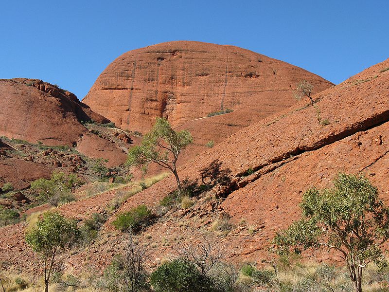
Kata Tjuta (The Olgas) as seen from the Valley of the Winds walk
(Photo: Sterry2607)
Kata Tjuta (The Olgas)
Just 27 km west of Ulura is another site of great interest. This is Kata Tjuta ("many heads" in the local Aboriginal language) or The Olgas as it has been known to the Europeans.
Kata Tjuta is a collection of 36 smaller, rounder rocks than Uluru (the explorer Ernest Giles called them "monstrous domes").
In an earlier era Kata Tjuta is believed to have been just one rock (a monolith) like Uluru is today but about ten times greater in the current size of Uluru.
Share this page:
Author: David Paul Wagner
(David Paul Wagner on Google+)
|